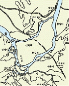
Songpa in Old Days
Jamsil-li in 1920
The village belongs to Ttukdo-myeon, Goyang-gun and is located in the south of Jamajang-li(Ttukseom), which includes 2 villages: one near the north shore is Shincheon-li and the one near the south shore is Jamsil-li.It was a peninsula connected to Jamajang-li, however it became an island after a small branch stream was created in the north shore due to a flood.
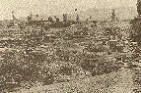
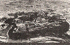
Songpa-li in 1925
It was on a hill in the south of Songpa ferry near Han river, where Songpa marketplace, one of the 15 major marketplaces, was held; due to heavy rain between July 9 and 17, 1925, the marketplace was destroyed and turned into a sandy plains and a river course.
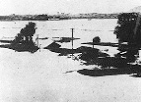
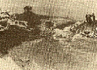
Han river shore sunken during the great flood in 1925
There was a heavy rain up to 383.7㎜ in Seoul for 4 days between July 9 and 12, 1925, which destroyed many houses and generated flood victims. People were busy drying their clothes and recovering the ruins. When rain started again 3 days later on the evening of July 15, people didn’t think it was serious but the rain turned into a heavy rainfall and continued for 5 days until July 19 with precipitation of 365.2㎜. The first and second flood called ‘the great flood in 1925’ resulted the maximum water level of Han river footbridge of 11.66㎜.
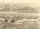
Jamsil before 1970
It was filled with mulberry trees in 1930s; since 1950s, residents removed the trees and started to grow vegetables and flowers including cabbages, radishes, cucumbers andpumpkins; there were 300 households in the area at that time.
Jamsil island water-blocking construction
Taeksik Yang, Seoul city mayor, and 500 residents participated in water-blocking construction between southeast of Jamsil island and Seongnaecheon, Songpa-dong onApril 15, 1971.(width of Han river at that time: 350m; depth, 4m.)
Mongchon Toseong before restoration
In 1977, outside of Mongchon Toseong near Seongnaecheon was used for cultivation; there were natural villages called ‘Mongchon’ on the east and west side of the south gate of ‘Jatnamugol’ in the northeast part of the fortress.
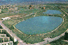
Songpa Ferry(Seokchon) Park before1980s
Original Han river became an artificial lake named Seokchon Lake by water-blocking construction in the south riverside of Jamsil island on April 15, 1971 and Shincheon, alarge river, became Han river. There were not many buildings but now the area has many tall buildings.
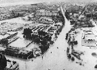
Now Wooil-ro during Pungnap flood
Pungnap-dong is facing Han river with high risk of flood. It was September 1 and 2, 1984 when the worst flood hit the area since 1925 and 1972. In the dawn of September 1, 1984, when 6 dams including Hwachoen, Uiam, Chuncheon, Cheongpyeong, Soyang and Paldang in the upper stream were filled with water, the water was discharged at the same time causing drastic raise of Han river water level resulting intervale near Han river sunken in water and overflowing reservoirs. 20,962 houses in 150 regions including Pungnap, Seongnae and Mangwon-dong were destroyed and estimated number of flood victims was 85,000.